Dantes View
Distance: 52 miles, round-trip
Time: 2 hours or longer
From the Furnace Creek Visitor Center, drive southeast on Highway 190 for three miles to Zabriskie Point. A short walk up to the overlook provides you with an excellent panoramic view of colorful badlands.
Proceed southeast on Highway 190 to Twenty Mule Team Canyon. This is a narrow one-way graded dirt road which is accessible to passenger cars (no trailers or RVs). The road winds through a series of scenic mudstone hills which are made of lakebed sediments left behind 7 to 9 million years ago. Watch for borax prospects — short tunnels dug by prospectors looking for major concentrations of borax. This road is about three miles long and loops back to connect with Highway 190.
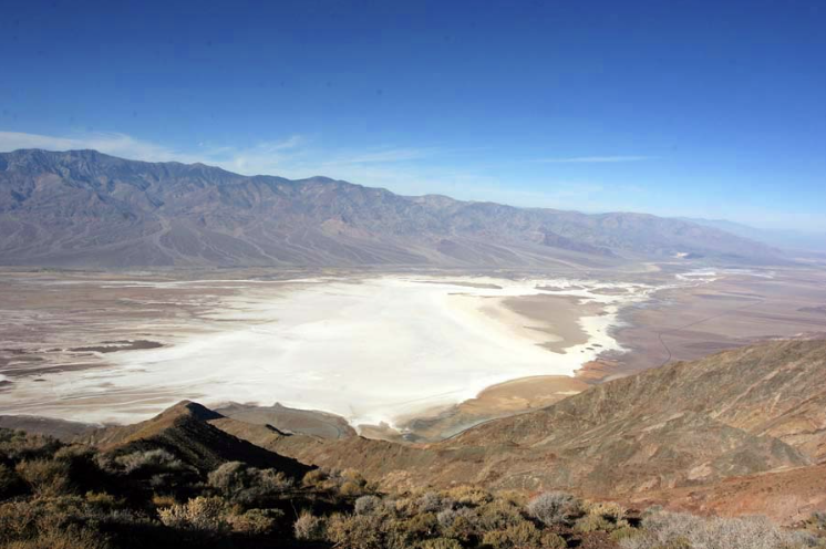
Continue driving southeast to the Dantes View turn-off on the right. Dantes View is 13 miles from this junction. The road climbs gradually until the last 1⁄4 mile, which climbs steeply at a 14% grade to the top of the ridge. The last 6 miles are closed to vehicles with a combined length of 25 feet or longer.
The view from the crest is quite spectacular. Temperatures at the top are generally 15 to 25 degrees cooler than on the valley floor, so take a jacket along during the fall, winter and spring. Hike out along the ridge in either direction for more views.
Badwater
Distance: 43 miles from Dantes View, 18 mi. from Visitor Center
Time: 11⁄2 to 2 hours or longer
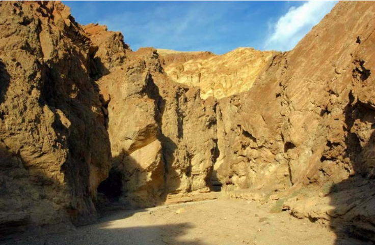
Due west of Dantes View is Badwater, a vertical mile below. To get to Badwater, retrace your route back toward Furnace Creek Inn, then turn left onto the Badwater Road. Two miles south is the Golden Canyon trailhead parking area. A one-mile interpretive trail winds through this colorful badland canyon.
Eleven miles south of Highway 190 is the Devil’s Golf Course (1.3-mile gravel road). The crystals left behind by the evaporation of an ancient lake are almost pure table salt(NaCl). They have been sculpted by wind and rain into sharp pinnacles.
A couple of miles past the turn-off to the Devil’s Golf Course, a rough two mile dirt road leads to the NaturalBridge parking area. A 1⁄2 mile walk leads up to the 50-foot high rock arch. Interesting erosional features line the canyon wall.
Another six miles down the road is Badwater, site of the lowest elevation in North America at 282 feet below sea level. Look for the sign on the cliff to the east that indicates sea level. Spring-fed
Badwater pool is home to a rare species of snail. Help protect them by not leaving the boardwalk in the pool area.
Walk on to the salt flats for a short distance to enjoy the expansive views up and down the valley and get a closer look at salt crystals. After heavy winter rains, the Badwater Basin can become covered with a temporary, shallow lake.
Artists Drive
Distance: 9 mile one-way loop road
Time: 30 minutes or longer
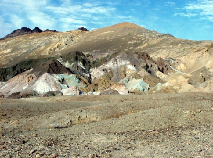
If you decide to return to Furnace Creek on the same road there is one more stop to make: the Artists Drive. This paved one-way loop road has sharp corners and steep dips. Vehicles over 25 feet in length are not allowed. The highlight, Artists Palette, is a multicolored hillside of reds, browns, greens and yellows; all the result of the oxidation or alteration of minerals in the sediments. Exiting from Artist’s Drive, turn right to return to Furnace Creek.
If you wish to continue the scenic drive south on the Badwater Road or exit Death Valley from the south via Highway 178, see reverse side.
South of Badwater
Faults and Turtlebacks
The drive south of Badwater is highlighted by dramatic views of the Black Mountains rising abruptly from the valley floor. These mountain slopes are the product of uplift along fault lines and stretching of the Earth’s crust that has caused blocks of crustal rocks to form the mountain ranges you see on either side of Death Valley. Rocks over a billion years old have been brought to the surface by this process. Look for evidence of these fault lines at the top of the alluvial fans along the base of the Black Mountains.
Some of the slopes of the Black Mountains are often referred to as Turtlebacks. This term is given to the friction smoothed surface of the fault line between the two blocks of crust. The surface has been eroded but the unweathered parts still can be seen in many places.
Located 13 miles south of Badwater near Mormon Point is a nice example of a Turtleback. The Mormon Point Turtleback is 5,000 feet high, about 3 miles long and one mile thick.
Shoreline Butte
Twenty miles south of Mormon Point lies Shoreline Butte. Composed of a volcanic rock called basalt, 1.5 million years old, Shoreline Butte has recorded one of Death Valley’s past climates in a unique way. As you look closely at the butte, you can see more than 20 horizontal benches. These benches were created by the splashing waves of Lake Manly, a huge lake that filled Death Valley during the end of the Pleistocene era, more commonly known as the Ice Age. Twenty-five thousand years ago, global temperatures were much cooler and precipitation higher than today.
Water accumulated in the region’s lowest place, Death Valley kind of like a huge bathtub with no drain. At its deepest, Lake Manly was 600 feet deep and 100 miles long. When global temperatures started to warm up ten to twelve thousand years ago, Lake Manly slowly evaporated, leaving just a few traces such as the terraces on Shoreline Butte.
Ashford Mill
South of Shoreline Butte is the Ash-ford Mill site. In 1910, Harold Ashford began work in the former claims of the Keys Gold Mining Company. In the mountains to the east, Ashford and his brother worked the mine for four years without striking results. They leased the mine to B.W. McClausland and his son Ross which led to the construction of a 180 ft. tunnel into the side of the mountain. The mill was built 5 miles south-west and 3,500 ft. below the mine. It employed 28 men and $100,000 worth of gold was extracted but the amount of money spent on the mine exceeded the profit of the gold and the mill was shut down. There were several attempts to reopen the mine in the ’20s and 30’s but none were successful.
Remember that historical artifacts are irreplaceable, so please do not climb on the ruins or collect artifacts.
Jubilee Pass
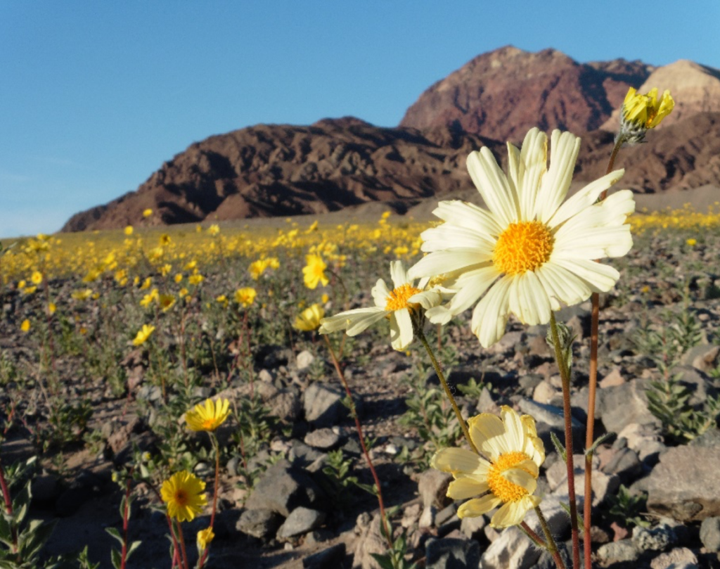
The next seven miles between Ash-ford Mill and Jubilee Pass are noted for having spectacular flower displays in years with adequate rainfall. Look for wildflowers in this area from March through April. Highway 127 and the small town of Shoshone are 21 miles west of the pass.
Harry Wade Road
Two miles south of Ashford Mill is an alternative exit of Death Valley for those with a 4×4 high-clearance vehicle. It was originally believed to have been the escape route for the Wade family, the only members of the lost pioneer wagon train that were able to leave Death Valley in 1849 with their wagons still intact.
The Harry Wade Road is signed for 4-wheel drive vehicles because of the crossing of the Amargosa River bed but can often be traveled by high clearance vehicles. Always check at the Visitor Center for current road conditions.
If traveling this route you will want to visit Saratoga Springs in the southern end of Death Valley. These springs are some of the largest freshwater springs in the northern Mojave Desert. They are a good place to look for birds and other wildlife as well as a unique species of pupfish.