Day Hikes
Easy Walks to Moderate Hikes
These hikes are short, but most can be extended if you feel like exploring.
[one_half]
1- Harmony Borax Works
Length: 0.4 mi (0.6 km) ADA accessible paved loop
Elevation Gain: 50 ft
Time: 30 minutes round trip
Season: Fall, Winter, Spring
Location: 1 mile (1.6 km) West of Furnace Creek on CA-190
Parking: Paved area with large spaces for RVs and buses
Closest Restroom: No restrooms. Furnace Creek Visitor Center 1 mile (1.6 km) east.
Route: Harmony Borax works interpretive trail is a 1/4 mile paved pathway that gains slightly in elevation as it leaves the parking lot. Areas of the pavement are cracked/crumbling, so watch your footing. The historic wagon and structures can be viewed from a distance from the parking lot and along the trail.
2 – Salt Creek
Length: 0.5 mi (0.8km) ADA accessible wooden boardwalk loop
Elevation Gain: Flat
Time: 30 minutes round trip
Season: Fall, Winter, Spring
Location: Salt Creek Road located 13 miles (20km) west of Furnace Creek on CA-190. The unpaved Salt Creek Road is typically passable to sedans.
Parking: The open gravel parking area is large enough for RV’s and buses.
Closest Restroom: Vault toilets are located in the parking lot.
Route: Visitors can view the pupfish and other species which rely on the water of the creek from a wooden ADA-accessible boardwalk which crisscrosses the creek. The boardwalk is a 0.5 mile (0.8 km) signed interpretive trail with information and benches along the way. Please be respectful of this VERY FRAGILE environment, and do not step off the boardwalk. The boardwalk is open year-round, however, water only flows down to the boardwalk from November through May. The best time to visit is during the Spring (February – April) when the Salt Creek Pupfish are in spawn.
3 – Badwater Salt Flat
Length: 1 mi (1.6 km) out and back round trip to edge of salt flat. 5 miles (8 km) each way to the other side
Elevation Gain: Flat
Time: Make your own adventure!
Season: Fall, Winter, Spring
Location: Badwater Road 30 minutes (17 miles/27km) south of Furnace Creek.
Parking: Paved parking lot with large spaces for RV’s and buses.
Closest Restroom: Vault toilet located in parking lot.
Route: An ADA accessible ramp leads down to a wooden boardwalk. The walking surface is firm and wide beyond the boardwalk. The pool and boardwalk are easily accessible from the parking lot off Badwater Road, but the best views of the salt polygons require an easy 1.5-2 mile (2.4-3.2 km) roundtrip walk out onto the salt flats. Be sure to look up on the cliffs of the Black Mountains to the east; here you will see a sign high above, indicating sea level. Also take a moment to pick out Telescope Peak in the Panamint Range to the west; at 11,049 ft (3, 368 m), this peak is over two miles (3.2 km) above you. Nowhere else in America can you see such a dramatic vertical relief over such a close distance.
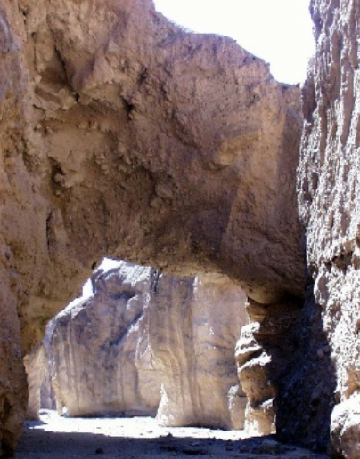
4 – Natural Bridge Canyon
Length: 1 mi (1.6 km) out and back round trip
Elevation Gain: 86 ft
Time: 45 minutes round trip
Season: Fall, Winter, Spring
Location: The unpaved Natural Bridge Road is 13.5 miles (22km) south of CA-190 on Badwater Road.
Parking: Open parking area large enough for buses and RV’s
Closest Restroom: Vault toilet located in parking lot.
Route: Natural Bridge parking area and trail head is accessed via a dirt road 13.5 miles (22 km) south of CA-190 off Badwater Rd. Although the road is typically well-maintained and accessible by most vehicles, washouts and deep ruts can occur, so check with a ranger for current conditions. A walk straight up the wash from the parking area will bring hikers directly under the bridge.The route from the information sign is easy to follow but very rocky. The canyon continues a short distance beyond the bridge where it abruptly ends at a dry waterfall.
[/one_half][one_half]
7 – Mesquite Flat Sand Dunes
Length: 2 miles (3.2 km) round trip out and back
Elevation Gain: 185 ft
Time: 1.5 hours round trip
Location: Located in Stovepipe Wells Village 30 minutes (24mi/39km) west of Furnace Creek.
Parking: Paved lot with pull through spaces for buses and large RV’s.
Closest Restroom: Vault toilets located in parking lot
Description: Area open for cross-country exploration; choose your own route to the tallest dune. The summit of the high dune is 1 mile (1.6km) each way with no formal trail. Graceful desert dunes, numerous animal tracks. The Mesquite Dunes are known for dramatic shadows at sunrise and sunset, as ripples and edges in the dunes stand out in greater contrast. They are also a great place to observe Death Valley’s famous dark night skies. No trail.
8 – Ubehebe Crater Loop
Length: 1.5 mile (2.4km) loop
Elevation Gain: 500 ft (152m)
Time: 1 hour round trip
Location: 8 miles (13km) west of Scotty’s Castle
Parking: The paved lot directly overlooks the crater and is large enough for buses and large RV’s.
Closest Restroom: No restrooms. Nearest restrooms are located at the unstaffed Grapevine Ranger Station 5 miles (8km) east of the crater.
Route: The hike is commonly done in a counter-clockwise direction where hikers begin with the uphill section first. This route leads past several smaller craters, including Little Hebe.Within 0.5 mi (0.8km) Little Hebe Crater comes into view and is a common destination for those looking for a shorter trip. Use caution around the craters’ exposed edges! This hike is not good for those with a fear of heights.
9 – Golden Canyon, Gower Gulch, and Badlands Loop
Length: 3 to 8 miles (5 to 13km) routes.
Elevation Gain: 535 ft to 834ft (163m to 254m).
Time: 1.5 to 4.5 hours round trip depending on route.
Locations:
- Golden Canyon trailhead located 2 miles south of CA-190 on Badwater Road.
- Zabriskie Point on CA-190 located 3.5 miles east of Badwater Road.
Parking: Paved lots at both locations. Large spaces for RV’s and buses.
Closest Restroom: Located in both parking lots.
Route: A maze of canyons and badlands create hiking opportunities galore. This hike has several route options depending on your activity level and desired difficulty. Go to the Golden Canyon page on the NPS website or visit the Furnace Creek Visitor Center for route details and a map.
10 – Desolation Canyon
Length: 3.6 mile (5.8km) out and back round trip
Elevation Gain: 600 ft (183m)
Time: 2.5 hours round trip
Season: Fall, Winter, Spring
Location: The short unpaved Desolation Canyon Road is located 3.7 miles (6km) south of CA-190 on Badwater Road.
Parking: Open gravel parking area.
Closest Restroom: No restroom at site. Golden Canyon parking lot 1.7 miles (2.7km) north has a vault toilet in the parking lot.
Route: This route is unmarked with rock scrambling required.Desolation Canyon runs along the western edge of the Black Mountains where a maze of drainages reveals colors reminiscent of neighbor Artist’s Palette. This unmarked cross country route is a great trip for hikers looking for an entry level cross country adventure.
11 – Darwin Falls
Length: 2 miles (3.2km) out and back round trip
Elevation Gain: 450 ft (137m)
Duration: 1.5 – 2 hours round trip
Season: Fall, Winter, Spring
Location: The unpaved Darwin Falls Road is located 1.2 miles (2km) west of Panamint Springs on CA-190. To the trailhead (first 2.5 mi/4km), Darwin Falls Road from CA-190 is typically passable to a sedan, however it is much more comfortable in a high clearance vehicle. Travelling from the town of Darwin to the trailhead is recommended for 4×4 high clearance vehicles only. Steep grades and unmarked intersections. Traveling to Darwin from the falls is not recommended.
Parking: Small gravel parking area. Not recommended for large RV’s.
Closest Restrooms: No restrooms. The nearest facilities are located at the privately owned Panamint Springs Resort.
Route: The route for this hike is unmarked. From the bulletin board at the parking area, head past the gate and into the wash up the canyon. The unmarked route is fairly flat but rocky as it transitions from a desert wash into a high walled canyon. Inside the canyon, thick vegetation, stream crossings, and large slick rocks require that hikers use caution as they work their way deeper into the oasis. Please protect this fragile resource. No swimming!
[/one_half]
[one_half]
Strenuous/Difficult Hikes
12 – Willow Canyon
Length: 4.2 miles (6.8km) out and back, round trip
Elevation Gain: 776 ft (237m)
Duration: 2.5 hours, round trip
Season: Fall, Winter, Spring
Location: An unmarked gravel access road is located on Badwater Road 31.5 miles south of CA-190 between mile markers 31 & 32. The access road is less than 0.5 miles (0.8km) long and is typically passable to a sedan. Same as Sidewinder Canyon.
Parking: Open gravel area large enough for buses and RV’s.
Closest Restroom: No restrooms nearby. Follow principle 3 of Leave No Trace (LNT).
Route: This route isn’t very physically demanding, but finding the canyon and seasonal waterfall is a reward that only cross country navigators get to enjoy. No road and no hiking route signage. From the parking area avoid the small foothills and canyons to the east. Instead make your way north/northeast wrapping around the foothills and head toward the deep canyon in the mountains. Most of this route is across the rocky alluvial fan and exposed to the sun. The last 0.25 miles (0.4km) into the narrow canyon is over polished bedrock before ending at the waterfall.
13 – Fall Canyon
Length: 6 miles (9.7km) out and back, round trip
Time: 3.5 hours round trip
Elevation Gain: 2,460 ft (752m)
Season: Fall, Winter, Spring
Location: The 2.7 mile (4.3km) unpaved two-way section of Titus Canyon Road is located 11.9 miles north of CA-190 on Scotty’s Castle Road.
Parking: Open gravel parking area not recommended for large RV’s or buses.
Closest Restroom: Vault toilet in the parking lot.
Route: From the mouth of Titus Canyon, find the footpath behind the primitive restroom. The path to Fall Canyon from the restroom runs northwest across alluvial fan deposits along the base of the towering Grapevine Mountains. After dropping down into a well-defined wash, follow the loose gravel into the drainage towards the mouth of Fall Canyon.
14 – Panamint Dunes
Length: 8 miles (12.8km) out and back
Elevation Gain: 1,028 ft (313m)
Time: 4-5 hours round trip
Season: Fall, Winter Spring
Location: Unmarked cross country route off the unpaved Lake Hill road, approximately 4.5 miles east of Panamint Springs on the north side of CA-190. Access to the trailhead requires a high clearance vehicle.
Parking: Small gravel lot.
Closest Restroom: Panamint Springs Resort or Emigrant Canyon Rest Station. No restroom along the trail, follow principle 3 of Leave No Trace (LNT).
Route: The unmarked route is uneven, sandy, and partially rocky. The elevation gain is gradual until you reach the dunes at approximate 3 miles in. From there, sandy and strenuous to the tops of 4 different dunes.
[/one_half][one_half]
Summer Hikes
Cool places to hike when the valley is too hot, but may be snow covered in winter.
15 – Wildrose Peak Trail
Length: 8.4 miles (13.5km) out and back, round trip.
Elevation Gain: 2,200 ft (671m)
Time: 6 hours round trip.
Season: Any, but trail conditions change dramatically throughout the year. Ask a ranger about current trail conditions.
Location: From CA-190 follow Emigrant Canyon Road past the Wildrose Campground to the parking area at the Charcoal Kilns. The final 2 miles is a maintained gravel surface typically passable in a sedan. 25 ft vehicle limit.
Parking: 25 ft vehicle limit. Open gravel area.
Closest Restroom: Vault toilet in parking area. No restroom along the trail, follow principle 3 of Leave No Trace (LNT).
Route: Wildrose Peak Trailhead is located at the historic Wildrose Charcoal Kilns. This is a great hike for when it starts getting too hot in the valley. Winter storms may bring snow and ice. The well-defined path leads you into the pinyon pine and juniper woodlands of the Panamint Mountains. Hikers will experience spectacular views beyond the 2 mile point. The hike has a steep grade for the final mile.
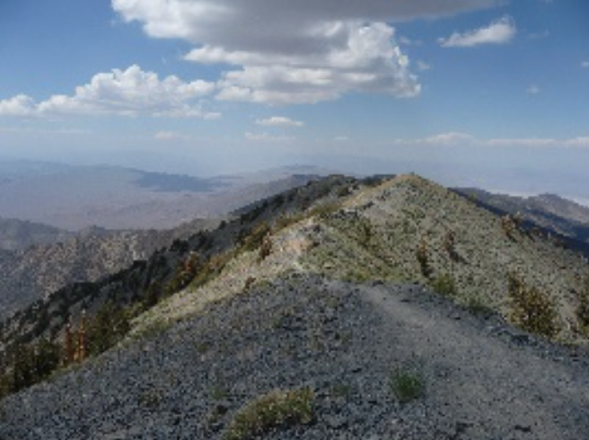
16 – Telescope Peak Trail
Length: 14 mile (22.5km) out and back, round trip
Elevation Gain: 3,000 ft (914m)
Time: 7 hours or more round trip
Season: Any, but trail conditions change dramatically throughout the year. Ask a ranger for current trail conditions.
Location: From CA-190 follow Emigrant Canyon Road past the Wildrose Campground to the parking area at the Charcoal Kilns. The final 5 miles is a maintained gravel surface typically passable in a sedan. 25 ft vehicle limit.
Parking: 25 ft vehicle limit. Open gravel area.
Closest Restroom: Vault toilet in parking area. No restroom along the trail, follow principle 3 of Leave No Trace (LNT).
Route: Trail to highest peak in the park (11,049 ft.) with a 3,000 ft. elevation gain. Climbing this peak in the winter requires ice axe and crampons, and is only advised for experienced winter climbers. Trail is usually snow-free by June. The trail immediately begins as a steady climb along the eastern slope of the Panamint Mountains, and continues to gain steadily in elevation for the entirety of the hike, ending at the 11,049 ft peak.
[/one_half]