Warning: vehicles longer than 25 feet are not allowed on this narrow, winding road.
Beginning at Furnace Creek, proceed west on Highway 190. You will pass several interesting places such as Salt Creek, the Sand Dunes, and Mosaic Canyon, but save these for later as you will need plenty of time to see the CharcoalKilns and AguereberryPoint.
Following Highway 190 past Stovepipe Wells Village, the road will begin to climb toward Towne Pass. At Emigrant Campground, turn left following the signs marked Wildrose and Trona. Warning: vehicles longer than 25 feet are not allowed on this narrow, winding road. The road ascends an alluvial fan and enters Emigrant Canyon. Interesting rock formations line this drainage named for the lost ‘49er pioneers, some of whom managed to escape the valley via this canyon. Beyond the canyon, narrows are the ruins of Journigan’s Mill, where a cyanide process was used to remove gold from ore mined at nearby gold mines.
Soon, the dirt side road to the site of Skidoo takes off to the left. High-clearance vehicles recommended. All that remains of this boomtown is a stamp mill hidden down a nearby gully.
Aguereberry Point
Distance: … 6-mile side road
Time: …… 1 hour or more
Turn left onto the road to Aguereberry Point. A sign recommends four-wheel drive, but conditions vary and it is often passable to passenger cars.
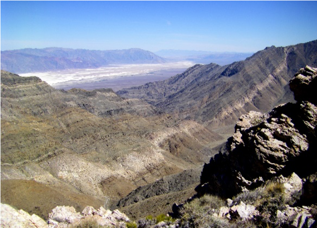
Check on road conditions at the Visitor Center before you leave. 11⁄2 miles beyond the turnoff is a short side road to Pete Aguereberry’s Eureka Mine. Beyond the Eureka Mine, the main road passes through a small canyon where a rocky outcrop can be a problem for low-clearance vehicles. A view into Death Valley is reached before the final 200 yards of the road, which is quite
steep. If you are driving a sedan or large camper, it is wise to stop here and walk. From the top are splendid views north and south along Death Valley and its surrounding mountains. Watch for the short path near the entrance to the parking lot. It leads out to the tip of the point for a great overlook of Furnace Creek and the badlands. Back on the main road, continue over Emigrant Pass and Nemo Crest. Much of the road is narrow and winding, so please drive carefully. Turn left at the next major junction and follow the paved road past Wildrose Campground. The Charcoal Kilns are 7-miles further up Wildrose Canyon. The last 2-miles of this road a regraded gravel, generally fine for vehicles with moderate ground clearance.
Charcoal Kilns

Distance: ..63 miles from Furnace Ck.
Time: …… 4 hours or more
An interpretive sign in the parking area describes these structures, which are over 100 years old. Take some time to explore the kilns and the surrounding pinyon pine/juniper woodland. From the kilns, a moderately strenuous hiking trail leads 4.2 miles to the summit of Wildrose Peak.
A steep gravel road recommended for high-clearance vehicles continues past the kilns to Thorndike and Mahogany Flat Campgrounds. The road and campgrounds are subject to winter closures because of snow and ice. When open, excellent views can be attained from Mahogany Flat, or you may want to explore the strenuous 7-mile long Telescope Peak Trail, which leads to Death Valley’s highest point.