* areas under the jurisdiction of the Bureau of Land Management (BLM).
Ballarat*
Chloride City
Chloride City became a town in 1905 when the Bullfrog strike brought people into the area to re-work old mining claims. It became a ghost town the following year. There are numerous adits and dumps in the area and one grave of a James McKay, of whom nothing is known.
In addition, there are remains of 3 stamp mills. It is located off a four-wheel-drive road 3.5 miles east of Hell’s Gate or off the dirt road 7 miles further east at the Park boundary. Turn right after the cattle guard.
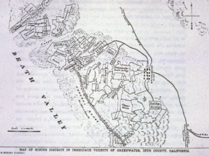
Greenwater
This town was built around a copper strike in 1905. Water had to be
hauled into the town and was sold for $15 a barrel. The town grew to a population of 2,000 and was known for its lively magazine, The Death Valley Chuckwalla. By 1909 the mining had collapsed without ever showing a profit and people left for other areas. There are no ruins left in Greenwater which is located south of Dante’s View off the unpaved, high-clearance, Greenwater Valley road.
Harrisburg
Originally this town was to be named Harrisberry after the two men who found the gold that launched it in 1905. Shorty Harris later took credit for the strike and changed the name of the town to Harrisburg after himself. Nevertheless, Pete Aguereberry, one of the original strike finders, spent 40 years working his claims in the Eureka gold mine. Harrisburg was a tent city that grew to support a population of 300. Today nothing remains of the town but Pete’s home and mine which are located to the right two miles down the dirt road to Aguereberry Point. For more information ask for the “Eureka Mine” handout.
Leadfield
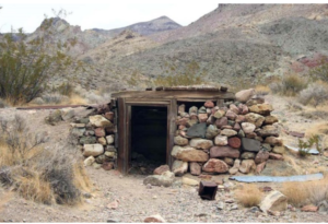
Copper and lead claims had been filed in the area as early as 1905 but it wasn’t until 1926 that the area was heavily mined. In February, Charles Julian, the flamboyant promoter became president of the town’s leading mining company, the Western Lead Mines. Julian’s promotions were responsible for bringing great numbers of people into the area and in April 1926 the town was laid out with 1749 lots.
Two things contributed to the demise of the town by 1927. One was the financial downfall of Charles Julian and the other was the playing out of lead in one of the main mines. The area is scattered with mines, dumps, tunnels and prospect holes. There are remains of wood and tin buildings, a dugout and cement foundations of the mill. The town is located on the Titus Canyon road. This is a one-way high-clearance, unpaved road that sometimes requires 4-wheel- drive and is routinely closed in the summer. For more information, ask for the handout on Leadfield.
Panamint City
It was called the toughest, rawest, most hard-boiled little hell hole that ever passed for a civilized town. Its founders were outlaws who when hiding from the law, found silver in Surprise Canyon in 1873 and gave up their life of crime. In 1874 the town was in the height of its boom with a population of 2,000 citizens. By the fall of 1875, the boom was over and in 1876 a flash flood destroyed most of the town. The chimney of the smelter is the most prominent remnant left. The site of Panamint City is accessible via a 5-mile hike from Chris Wicht’s Camp located 6 miles northeast of Ballarat. Mining in the area has continued on a sporadic basis up into recent times. The ruins of old Panamint City were added to Death Valley National Park in October of 1994.
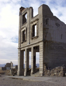
Rhyolite*
This was the biggest town in the Death Valley area boasting a population of 5,000-10,000 people. During its heyday from 1905-1911, it contained 2 churches, 50 saloons, 18 stores, 2 undertakers, 19 lodging houses, 8 doctors, 2 dentists, a stock exchange and an opera. The town contains numerous ruins including a Bottle House, the train depot, remains of a 3 story bank building and the jail. It is on BLM land and is accessible by passenger car. Rhyolite is located 4 miles west of Beatty and 35 miles from the Furnace Creek Visitor Center. For more information, ask for the handout on Rhyolite.
Skidoo
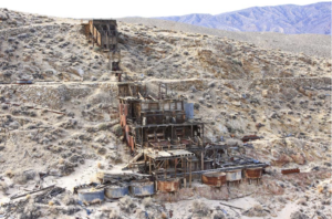
This town was founded in 1906 when 2 prospectors were on their way to the strike at Harrisburg and found gold. The town reached a population of 700 and became famous as the site of the only hanging to take place in Death Valley. It occurred when Hootch Simpson, a saloon owner who had fallen on hard times, tried to rob the bank, was foiled in the attempt, and later went back and killed the owner of the store in which the bank was located. During the night the townspeople hanged Hootch. According to legend, he was hanged twice. The second hanging was to accommodate news photographers who missed the first hanging. No one was ever arrested for the hanging of Hootch Simpson.
Skidoo is located off the Wildrose road on a high-clearance, unpaved road. Nothing remains of the town except the old mill, located in a gully to the west of the townsite. An information handout about Skidoo is available.